
1. Create a database with records of CAS and STR and fast service broadcast RTCM. The schema is very simple.
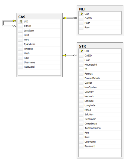
2. Simple console program (C# .NET 2.0) collects CAS and STR records to database.

I used the site http://rtcm-ntrip.org:2101 as root site.
The total number of unique CAS records (servers) = 280. The total number of STR records = 8822.
For DGPS support, I use only RTCM 2/3 mountpoints = 6934 records.
3. Query to find the STR channel using coordinates (also possible to use the Cell ID data from GSM module and opencellid to approximate the coordinates.)
declare @Latitude real, @Longitude real
select @Latitude = 55.5, @Longitude = 36.7
select
dbo.GeoDistance(S.Latitude, S.Longitude, @Latitude, @Longitude) AS Distance,
S.Mountpoint,C.Host,C.Port,
S.NMEA, S.NavSystem, S.Format, S.FormatDetails, S.Fee, S.Authentication,
isnull(isnull(S.Username,C.Username),'') as [Username],
isnull(isnull(S.Password,C.Password),'') as [Password]
from
[STR] as S, [CAS] as C
where
([Latitude] is not null)
and ([Longitude] is not null)
and (Latitude between (@Latitude - 4.0) and (@Latitude + 4.0))
and (Longitude between (@Longitude - 4.0) and (@Longitude + 4.0))
and (dbo.GeoDistance(Latitude,Longitude, @Latitude, @Longitude) < 500000.0)
and (C.[UID] = S.[CASID])
order by Distance asc
Distance(m) Latitude Longitude Mountpoint Host Port NMEA NacSystem Format Format-Details Fee Authentication
4388.535 55.52 36.76 ZWE20 139.17.3.112 4080 0 GPS RTCM3.0 1004(1),1006(10),1007(10) N B
178066.1 56 34 56N034E www.egnos-ip.net 2101 0 GPS RTCM 2.0 1(1.8),3(180) N B
329013.8 53 34 53N034E www.egnos-ip.net 2101 0 GPS RTCM 2.0 1(1.8),3(180) N B
422100.1 59 34 59N034E www.egnos-ip.net 2101 0 GPS RTCM 2.0 1(1.8),3(180) N B
4. Use the first two entries (4.5 km and 178 km). To receive data from Mountpoint must have a name and password.
To be continued ...

0 comment(s) so far